Tag Archives: walk

To the Cliffs – Part 2

We walked up a long stretch of coastal scrub, until we could see the landscape all the way down to the high hills above Burning Palms.

Coastal Walk from Wattamolla

Tea tree bushes seemed to dominate here, but there was plenty of summer flowers about to break up the scene, whether they be in the trees…

Coastal Walk from Wattamolla

Or closer to the ground.

Coastal Walk from Wattamolla

Coastal Walk from Wattamolla

After spending some time in Europe, I think we’re very lucky here in Eastern Australia to have something flowering all year round.

Coastal Walk from Wattamolla

To the Cliffs – Part 1

Another national park that we’ve not visited in a long time was the Royal National Park. And it’s been even longer since I took a walk to the cliffs. It’s time to remedy that.

We started at Wattamolla on a warm summer’s day. The park was already bustling with people even though it was just 10.30am. We crossed Wattamolla Creek and headed north past sparse eucalypt forest. The boulders here were a highlight, marking the edge of the forest and the low coastal scrub.

Coastal Walk from Wattamolla

Coastal Walk from Wattamolla

Blue Mountains Winter Weekend – Part 1

Now that I’ve finished posting about our travels abroad, I can concentrate on catching up on our activities here in the last 6 months. Last August we spent a weekend in the Blue Mountains to celebrate our wedding anniversary. One thing we did was take a walk along the Charles Darwin Walk.

Charles Darwin Walk

It had been some years since I walked this track, and I was glad to see the pre-spring wildflowers out.

Charles Darwin Walk

Charles Darwin Walk

It was always a treat to see the waterfalls.

Charles Darwin Walk

And of course, the grand view from Wentworth Falls at the end.

Charles Darwin Walk

Oulu – Part 3

We didn’t have a car while in Oulu, and so spent a lot of time on the buses and walking. One day after dinner at a friend’s place, we walked in the twilight back to our cabin. On the way, we passed a lot of birch trees, the predominant species in Finland. They were still rather bare in early May, but their pale trucks reflected the wonderful golden light.

Nallikari

We walked by a lot of water along the way. Oulu has been built on the inlet of a river, and the city has really embraced the water. Again, it’s a place that has been built into the landscape.

Walking to Hietasaari

The locals also love the outdoors, and take to it whenever possible, whether on land (nordic walking, cycling and rollerblading being favourite summer pasttimes) or on water.

Walking to Hietasaari

Oulu is also a growing city. It has a top-class university, forestry (still mainly traditional woodchipping – the chimney is for the pulp mill), and technology – Nokia has its research and development base there. It all requires new accommodation, hence the presence of these cranes.

Walking to Hietasaari

As we got closer to the coast, the sky became more spectacular.

Nallikari at dusk

Until it gave a fitting finale.

Nallikari at dusk

Oulu – Part 2

Our cabin was by the sea – well, by the Gulf of Bothnia, which flows into the Baltic Sea. We explored the area by bike and foot as there were excellent paths along this stretch. As with much of Finland, the area was flat, characterised by reed marshes.

Nallikari

Being so flat, it could also get very windy – a great place to put a wind turbine.

Cycling in Oulu

But it wasn’t all wild marshes. As I mentioned, there were also beaches – two that I found. One of them wasn’t all that developed, just a place to kick back and enjoy the sea.

Cycling in Oulu

The other was the main beach of Oulu. It had showers, toilets, decking, a cafe and lookout, even an American-style lifeguard tower.

Nallikari

But look carefully at the photo, what is that on the water? Could it be ice? You bet ya. It was the last remains of the winter pack ice. It made a spectacular scene at sunset, but it certainly didn’t look like somewhere to take a dip, at that time of the year, at least.

Nallikari at dusk

Farewell to Greece

We farewell Santorini, and Greece, with a little walk through the village of Pyrgos Kallistis. This village is a bit out of the way from Fira and the other caldera towns, but it does give a good view of the island. To get to the lookout, we needed to wander around its narrow, whitewashed streets.

Pyrgos Kallistis

We passed a church or two on the way to the top of the village.

Pyrgos Kallistis

Pyrgos Kallistis

And some tantalising glimpses of the view.

Pyrgos Kallistis

At the top of the town, an old fort, we were able to see Santorini in all its glory. A fitting end to our odyssey around Greece.

Pyrgos Kallistis

We’re not done with Europe just yet. Next, we’re heading north.

Santorini – Part 4

We still had a long way to go yet – past that church with the blue dome at the top of the hill.

Santorini Clifftops

On the way, we passed a few other churches. There was certainly an abundance of them on this part of the island.

Santorini Clifftops

Santorini Clifftops

At least because of tourism, much of the old architecture has been preserved, like this old windmill.

Santorini Clifftops

There was of course some more jaw-dropping views of the caldera.

Santorini Clifftops

And after two hours of walking, we finally reached the end of the road. What a view it was.

Santorini Clifftops

I would have loved to stay here for a week, but much of the accommodation at the end of the road was still closed.

Santorini Clifftops

And now for the journey back down. With views like this, it wasn’t much of a hardship.

Santorini Clifftops

Santorini – Part 3

Let’s take a walk. As I mentioned before, the main villages in Santorini are located along the cliff tops. They must have been distinct villages at one stage, but these days they have merged into one long village. We start off at the quarry, opposite our hotel. The town of Fira looms large.

Fira

A wander down the back alleys took us past a church, where the bell-ringer was getting a morning work-out.

Fira

Fira

The hotels and pensions were stacked way down the cliff side in this area. Even though the view would be great, I wouldn’t fancy a 100 stair walk everytime I wanted something.

Fira

Looking up, we had a long, long way to go yet.

Fira

There was option to take the easy way up, if you’re coming in from the bottom of the cliff off the ships. But we came by plane and so came by taxi.

Fira

Fira

Soon we were able to stop at a cafe, and admire the view.

Fira

But don’t go away as we’re only halfway through the walk!

Cornish Mining – Part 4

We didn’t just visit the Geevor and Levant mines, but walked south along the Coast Path to find other remnants of mining. Nowadays, the land has been turned back to grazing, mainly that of sheep. As with walking in the British Isles, there were a few stiles over stone fences to navigate over.

Walking the Coast Track

Sure enough, there were abandoned buildings and stacks all along the coast.

Walking the Coast Track

And the British weather never failed to surprise. We saw our fair share of rainbows that day.

Walking the Coast Track

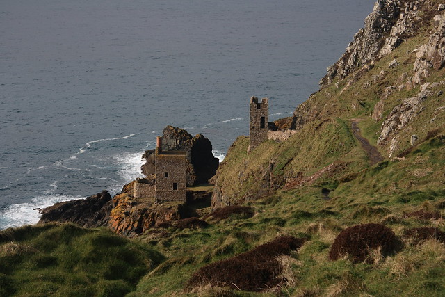
But the weather cleared up just as we reached the Botallack mine site. This is also a World Heritage site, and is probably the most scenic mine sites you will ever see.

Walking the Coast Track

Walking the Coast Track

Where’s the mine, you say? The shaft entrance is down the bottom of the cliff. Needless to say, the miners got very wet when the tides were high. The miners dug shafts up to 500 metres deep and 400 metres out to sea. Once again, it was hard and dangerous work.

Walking the Coast Track

But as international trade ramped up during the Industrial Revolution, local mining work such as that in Cornwall dried up. Many Cornish miners immigrated abroad to find a better life. There are now descendants of these miners in USA, Canada, South Africa, Mexico, Brazil, Australia (in South Australia) and New Zealand (which I visited and will post about one day). It certainly explains how pasties and rugby and soccer got to all those places.